
The ninth installment in a monthly series in which a hometown Richmonder who has spent over a decade abroad explores the many different neighborhoods accessible by GRTC bus lines to discover the ways transit connects us all.

Northside:
If one were to make a Northside bingo game, the word that would be at the very center of the board — the freebie — would be “potential.” Whether you live, work, or just hang out at one of the area’s charming breweries, cafés, or restaurants, the waves of change lapping at each and every neighborhood are almost palpable.
Like the East End, “Northside” represents an amalgamation of many distinct neighborhoods, ranging from Highland Park to Bellevue and from Ginter Park to Gilpin. However, the one stretch of Northside that best encapsulates the area’s economic, demographic, and cultural change is Brookland Park Boulevard.

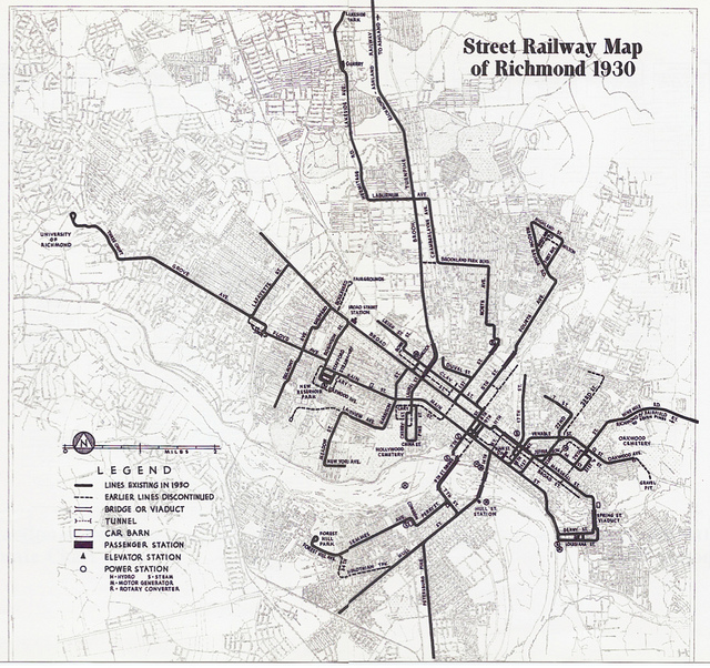
As streetcars stretched ever further north from Richmond’s downtown, developers plotted out leafy neighborhoods, often called “parks,” along each trolley line. The new residents enjoyed their easy connectivity to the downtown via the streetcars, but still wanted neighborhood establishments to cater to their needs. Thus in each development a commercial strip was set aside: MacArthur Avenue in Bellevue, Six Points in Highland Park, and Brookland Park Boulevard at the heart of it all.
Sandwiched between the wealthy neighborhoods of Battery Park, Ginter Park Terrace, Barton Heights, and the eponymous Brookland Park, this boulevard became one of Richmond’s premier commercial corridors, featuring banks, boutiques, bakeries, and even a theater. The former affluence is visible in the stately bungalows and American Foursquare architecture that permeates the surrounding neighborhoods.

The White flight and suburbanization of the post-WWII era drained the area of its prosperity as residents abandoned property and fled the city en masse, seeking to raise their children in the “right” (read: mostly White) communities. Disinvestment and the prioritization of the personal automobile further damaged the corridor through razed storefronts and the addition of hideous parking lots.
The establishment of the Brookland Park Historic District in 2003 and the corresponding historic rehabilitation tax credits provided the first chance at rejuvenating the corridor for the Black residents and business owners working to spruce up the boulevard. Over the past five years, those seeds of growth have begun to blossom into a coterie of small businesses along the corridor, including Shrimps, Boogaloos, Michaela’s Quality Bake Shop, and Nomad Deli.
The more recent openings of a yoga studio, dog groomer, and coffee shop demonstrate that it’s not just longtime residents who see the potential of Brookland Park Boulevard. The claim that this will become a second Carytown both excites and worries nearby residents, depending on where they rank on the socio-economic ladder.
The proliferation of brightly painted front doors, state school flags hanging from porches, and fenced-in backyards serve as canaries in the coal mine of displacement. In 2012 only three percent of Barton Heights residents were White. Since then sixty-eight percent of home-buyers have been White, however. In another generation, much of Northside may become prohibitively expensive to those who pioneered the area’s restoration.
Although gentrification has made this beloved Northside corridor safer (minus the wild speeding and lack of pedestrian amenities), without changes to liberalize the surrounding neighborhoods’ zoning from single-family use only, many existing residents will be priced out of their homes. Ending the ban on multi-family zoning across Richmond, legalizing accessory dwelling units, and introducing ten-year averages of property values for taxing could all weaken the tide of displacement and foster a more inclusive Northside. If Richmond does nothing, then most current residents will be pushed into the counties before they ever get to enjoy Brookland Park Boulevard’s full revitalization.

The Ride:
On Saturday mornings Brookland Park Boulevard can feel like a ghost town. Even the confusingly named Café Nostra — which often feels like a reluctant outpost of Black Hand Coffee Co. rather than a true coffee house — was empty save the singular employee behind the counter. With a smile and a joke about the lack of customers, we had our coffees in hand and were ready to catch the Greater Richmond Transit Company’s Route 2 southward.
Joining me for this month’s ride was long time Northsider, WRIR Volunteer Coordinator, and co-founder of RVA Dirt, Melissa “Busy Bee” Vaughn. Although we wanted the 2A or 2B that pass by Forest Hill Park, we were unwilling to wait another fifteen minutes and hopped on the 2C.
The 2C to the McGuire VA Hospital runs once every thirty minutes. The 2A and 2B that deliver passengers to Stony Point and Chippenham, respectively, only run once per hour. The overlap of these two until Westover Hills Boulevard creates a 30-minute frequency up to that point as well. This staggering of route variations allows the trunk of the line to have the desired fifteen-minute intervals, which studies show is the minimum frequency required at which people will choose to live car-free.

As we trundled through Barton Heights and Gilpin, the bus gradually picked up passengers until, by Broad Street, it was standing room only. The electronic display that shows the name of the next stop intermittently flashed the number for the housing crisis line hotline — an ingenious advertisement for anyone homeless who may have bought a bus ticket just to get out of the cold for a while.
A zippy half-hour later we alighted the bus along Midlothian Turnpike (thanks to our choice of the 2C) and began to walk down Dundee to the heart of Forest Hill, where its eponymously named avenue intersects with Semmes Avenue. After passing houses ranging from quirky to charming and downright spooky, we came to the stop in front of WPA’s Southside bakery.
Here the bench and trash can amenities GRTC installed are an inexplicable 50-plus feet from the actual stop. The inconvenience to riders waiting on the bus is clear. The reason the stop got moved so far away from its amenities will likely remain a mystery in perpetuity.
Forest Hill:

Anyone could guess the history of Forest Hill from 1728 to 1889. It should come as no surprise that a large swath of land just beyond city limits was owned by a series of entitled White men who took advantage of slave labor to build palatial abodes upon the grounds of their country residence.
It is only after William Byrd III squandered his family’s immense inherited wealth on gambling, bad investments and the boondoggle that is the mansion at Westover Plantation does the story of Forest Hill’s history get good. In an attempt to avoid bankruptcy, Byrd sold his family’s 179,000 acres of Virginia land and hundreds of enslaved people, but was still unable to fully pay off his creditors. Despondent, he committed suicide, leaving his wife and fifteen children to fend for themselves.
His vast estate on the southern bank of the James eventually landed in the lap of the Richmond and Manchester Railway Company. Seeing a chance to expand, in 1890 the company extended their Semmes Avenue line all the way down Forest Hill Avenue to 41st Street. From Manchester out to today’s Forest Hill Park, frame bungalows and homes built in the Colonial Revival, Tudor Revival, and Mission Revival styles sprouted up along the route.

To incentivize ridership on their new route, the railway company employed an unorthodox tactic: they constructed Richmond’s first ever amusement park. Long before the dawn of King’s Dominion, River City residents would hop a streetcar south to ride the roller coaster and enjoy a day of merriment at Forest Hill Park. Beyond the big-ticket rollercoaster, the attractions on offer eventually grew to include a fun house, a carousel, a swimming area, a skating rink, a dance hall, a penny arcade, a golf course, a bath house, outdoor “moving pictures,” and even a boating lake in the former quarry on the premises.

The Great Depression heralded the end of Richmond’s first rollercoaster, and the railway company ceded the land to the City to become a public park. Between 1935 and 1943, craftsmen and stone masons sent by Roosevelt’s Works Progress Administration tore down the wooden amusement structures, paved the park’s paths, and even planted an azalea garden. The work completed in that era laid the foundation for what has become Southside’s largest and most beloved greenspace.
Over the years Forest Hill has garnered a reputation as a placid, verdant corner of the city filled with large lots, quiet streets, and tidy single-family homes. The attractiveness of both its reputation and its location, however, look set to add a denser, more lively flair to the area.

Later this year, developers Birck Turnbull and Charles Bice will open a new mixed-use project at the intersection of Forest Hill Avenue and Westover Hills Boulevard, at the junction of GRTC’s Route 2 and Route 20. The new development will bring 38 apartments and 12,000 square feet of commercial space to what is currently a vacant lot. Anchoring the project are some popular Richmond brands: Charm School Social Club, a Boho Yoga Studio, Stella’s Grocery, The Veil Brewing Co, and Blanchard’s second café.
After decades of disinvestment and depopulation, it’s clear that Richmond is on the rise. The economic pressure of a growing local economy and job market mean Northside and Forest Hill are in flux. By channeling development onto two of the area’s busiest corridors, Forest Hill is charting the way forward for Richmond to accommodate our city’s growing population.
As a city, we face a choice as to what our future development looks like. We can either do nothing and thus allow the displacement of many of our longtime friends and neighbors, or we can change our zoning to be more inclusive and repurpose underutilized lots to build new housing along transit routes. Nothing can stop the gentrification of our city (and we shouldn’t even want to), but we as Richmonders get to choose our path forward: displacement or density.
Top Photo courtesy Architecture Richmond. Historic photos via The Valentine archives.

